the Upper St. John River Organization
helping to Sustain our Watersheds and our Acadian Forest
Our Vision
The Upper St. John River Organization will contribute to sustainability of the region by increasing knowledge and awareness of the many values of our forests, aquatic systems, and other natural resources, and providing services for their conservation, sustainable management, and sustainable development.
Our Mission
The Upper St. John River Organization will help to sustain our natural resources by providing planning, organization, project management, field work, and GIS-based information technology services and support for projects related to natural resource conservation and management, natural science education, outdoor recreation, and sustainable development.
Our Geographic Scope
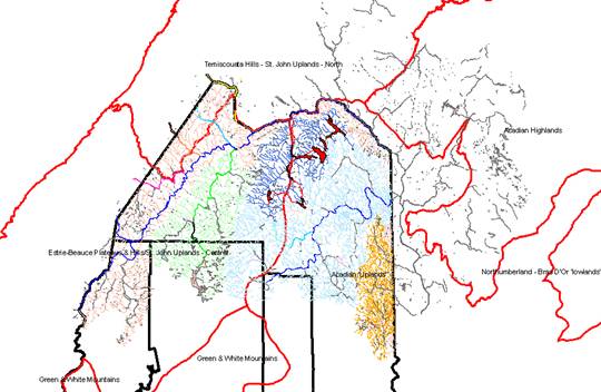
The geographic of the USJRO includes the sub-watershed areas of the St. John River in the international border area of the United States and Canada.
Watersheds shared between the United States and Canada in this region include the Big Black River, Chimenticook Stream, and Little Black River, which drain to the St. John River in the United States from the province of Quebec, Canada, and the St. Francis River (called the St. Francois in New Brunswick), Aroostook River, and Meduxnekeag Rivers that traverse Maine and New Brunswick enroute to the St. John River.
Watersheds contained entirely in the United States or Canada draining to the St. John River at or near the international border are also included in the scope of the USJRO including: The Fish River Chain of Lakes, which is found entirely in Maine, and the Madawaska River, Green River, and Tobique River watersheds, which are contained entirely in New Brunswick, Canada.
The main office and executive directorship of the Upper St. John River Organization will be located in the St. John River Valley in the U.S., and >50% of the Directorship of the USJRO will be located on the U.S. side of the border.
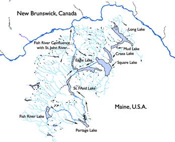
The Upper St. John River Organization is a resurrection of the Fish River Lakes Water Quality Association with expanded area and scope. The Fish River Chain of Lakes will continue to be a focus area for the USJRO.
The Fish River Chain of Lakes is comprised of 8 large lakes in northern Maine totaling 25,000 acres. These lakes are connected to each other by the Fish River, which empties into the St. John River at Fort Kent, Maine and Claire, New Brunswick, Canada. There are two major sources of flow in the Fish River chain. One flow begins at Long Lake, which flows southwest to Mud Lake, then Cross Lake, then Square Lake, then Eagle Lake, which drains north to the St. John River. The other flow begins at Fish River Lake, the highest elevation lake in the chain, which flows southeast to Portage Lake, then north to St. Froid Lake, which drains north to Eagle Lake, again finally draining north to the St. John River in Fort Kent.
.